World Facts Index
 The
exact origins of the Nauruans are unclear, since their language does not
resemble any other in the Pacific. The island was annexed by Germany in 1888 and
its phosphate deposits began to be mined early in the 20th century by a
German-British consortium. Nauru was occupied by Australian forces in World War
I and subsequently became a League of Nations mandate. After the Second World
War - and a brutal occupation by Japan - Nauru became a UN trust territory. It
achieved its independence in 1968 and joined the UN in 1999 as the world's
smallest independent republic. The
exact origins of the Nauruans are unclear, since their language does not
resemble any other in the Pacific. The island was annexed by Germany in 1888 and
its phosphate deposits began to be mined early in the 20th century by a
German-British consortium. Nauru was occupied by Australian forces in World War
I and subsequently became a League of Nations mandate. After the Second World
War - and a brutal occupation by Japan - Nauru became a UN trust territory. It
achieved its independence in 1968 and joined the UN in 1999 as the world's
smallest independent republic.
Geography of Nauru
|
Location:
|
Oceania, island in the
South Pacific Ocean, south of the Marshall Islands |
|
Coordinates:
|
0 32 S, 166 55 E |
|
Area:
|
total: 21 sq km
water: 0 sq km
land: 21 sq km |
|
Area comparative:
|
about 0.1 times the size of
Washington, DC |
|
Land boundaries:
|
0 km |
|
Coastline:
|
30 km |
|
Maritime claims:
|
contiguous zone: 24
NM
territorial sea: 12 NM
exclusive economic zone: 200 NM |
|
Climate:
|
tropical; monsoonal; rainy
season (November to February) |
|
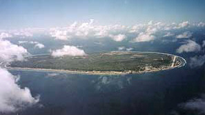
Terrain:
|
sandy beach rises to
fertile ring around raised coral reefs with phosphate plateau in center |
|
Elevation extremes:
|
lowest point:
Pacific Ocean 0 m
highest point: unnamed location along plateau rim 61 m |
|
Natural resources:
|
phosphates, fish |
|
Natural hazards:
|
periodic droughts |
|
Environment current issues:
|
limited natural fresh water
resources, roof storage tanks collect rainwater, but mostly dependent on
a single, aging desalination plant; intensive phosphate mining during
the past 90 years - mainly by a UK, Australia, and NZ consortium - has
left the central 90% of Nauru a wasteland and threatens limited
remaining land resources |
|
Geography - note:
|
Nauru is one of the three
great phosphate rock islands in the Pacific Ocean - the others are
Banaba (Ocean Island) in Kiribati and Makatea in French Polynesia; only
53 km south of Equator
|
Population of Nauru
|
Population:
|
13,770 (July 2008 est.) |
|
Age structure:
|
0-14 years: 36.9% (male 2,507/female 2,391)
15-64 years: 61.2% (male 4,004/female 4,123)
65 years and over: 2% (male 139/female 123) |
|
Median age:
|
20.6 years |
|
Growth rate:
|
1.81% |
|
Infant mortality:
|
9.78 deaths/1,000 live births |
|
Life expectancy at birth:
|
total population: 63.08 years
male: 59.5 years
female: 66.84 years |
|
Fertility rate:
|
3.11 children born/woman |
|
Nationality:
|
noun: Nauruan(s)
adjective: Nauruan |
|
Ethnic groups:
|
Nauruan 58%, other Pacific Islander 26%,
Chinese 8%, European 8% |
|
Religions:
|
Christian (two-thirds Protestant, one-third
Roman Catholic) |
|
Languages:
|
Nauruan (official, a distinct Pacific
Island language), English widely understood, spoken, and used for most government and
commercial purposes |
Government
|
Country name:
|
conventional long form: Republic of
Nauru
former: Pleasant Island |
|
Government type:
|
republic |
|
Capital:
|
no official capital; government offices in
Yaren District |
|
Administrative divisions:
|
14 districts; Aiwo, Anabar, Anetan,
Anibare, Baiti, Boe, Buada, Denigomodu, Ewa, Ijuw, Meneng, Nibok, Uaboe, Yaren |
|
Independence:
|
31 January 1968 (from the Australia-, NZ-,
and UK-administered UN trusteeship) |
|
National holiday:
|
Independence Day, 31 January (1968) |
|
Constitution:
|
29 January 1968 |
|
Legal system:
|
acts of the Nauru Parliament and British
common law |
|
Suffrage:
|
20 years of age; universal and compulsory |
|
Executive branch:
|
chief of state: President Marcus STEPHEN (since
19 December 2007); note - the president is both the chief of state and head of
government
head of government: President Marcus STEPHEN (since 19 December 2007); note -
President Ludwig SCOTTY defeated in a no confidence vote in parliament on 19
December 2007
cabinet: Cabinet appointed by the president from among the members of Parliament
elections: president elected by Parliament for a three-year term; election last
held 19 December 2007. |
|
Legislative branch:
|
unicameral Parliament (18 seats; members elected by
popular vote to serve three-year terms) |
|
Judicial branch:
|
Supreme Court |
|
Political parties and leaders:
|
loose multiparty system; Democratic Party [Kennan ADEANG];
Nauru Party (informal); Nauru First (Naoero Amo) Party |
Economy
Revenues of this tiny island have traditionally come from exports of
phosphates, now significantly depleted. An Australian company in 2005 entered
into an agreement intended to exploit remaining supplies. Few other resources
exist with most necessities being imported, mainly from Australia, its former
occupier and later major source of support. The rehabilitation of mined land
and the replacement of income from phosphates are serious long-term problems.
In anticipation of the exhaustion of Nauru's phosphate deposits, substantial
amounts of phosphate income were invested in trust funds to help cushion the
transition and provide for Nauru's economic future. As a result of heavy
spending from the trust funds, the government faces virtual bankruptcy. To cut
costs the government has frozen wages and reduced overstaffed public service
departments. In 2005, the deterioration in housing, hospitals, and other
capital plant continued, and the cost to Australia of keeping the government
and economy afloat continued to climb. Few comprehensive statistics on the
Nauru economy exist, with estimates of Nauru's GDP varying widely.
|
GDP:
|
$60 million (2005 est.) |
|
GDP per capita:
|
$5,000 |
|
Inflation rate:
|
-3.6% |
|
Labor force - by occupation:
|
employed in mining
phosphates, public administration, education, and transportation |
|
Unemployment:
|
90% |
|
Budget:
|
revenues: $13.5 million
expenditures: $13.5 million |
|
Electricity production by source:
|
fossil fuel: 100%
other: 0% |
|
Industries:
|
phosphate mining, offshore
banking, coconut products |
|
Agriculture:
|
coconuts |
|
Exports:
|
phosphates |
|
Export partners:
|
South Africa 57%, India 15.5%, Canada 5.6% |
|
Imports:
|
food, fuel, manufactures,
building materials, machinery |
|
Import partners:
|
Australia 57.2%, US 9.3%, Germany 7.8%, Indonesia
7.4% |
|
Currency:
|
Australian dollar (AUD) |
SOURCES: The CIA World Factbook, U.S. Department of State, Area Handbook of the US Library of Congress
Copyright 2004 - 2008 worldfacts.us |