World Facts Index
 Although
known to Arab and Malay sailors as early as the 10th century, Mauritius was
first explored by the Portuguese in the 16th century and subsequently settled by
the Dutch - who named it in honor of Prince Maurits van NASSAU - in the 17th
century. The French assumed control in 1715, developing the island into an
important naval base overseeing Indian Ocean trade, and establishing a
plantation economy of sugar cane. The British captured the island in 1810,
during the Napoleonic Wars. Mauritius remained a strategically important British
naval base, and later an air station, playing an important role during World War
II for anti-submarine and convoy operations, as well as the collection of
signals intelligence. Independence from the UK was attained in 1968. A stable
democracy with regular free elections and a positive human rights record, the
country has attracted considerable foreign investment and has earned one of
Africa's highest per capita incomes. Recent poor weather, declining sugar
prices, and declining textile and apparel production, have slowed economic
growth, leading to some protests over standards of living in the Creole
community. Although
known to Arab and Malay sailors as early as the 10th century, Mauritius was
first explored by the Portuguese in the 16th century and subsequently settled by
the Dutch - who named it in honor of Prince Maurits van NASSAU - in the 17th
century. The French assumed control in 1715, developing the island into an
important naval base overseeing Indian Ocean trade, and establishing a
plantation economy of sugar cane. The British captured the island in 1810,
during the Napoleonic Wars. Mauritius remained a strategically important British
naval base, and later an air station, playing an important role during World War
II for anti-submarine and convoy operations, as well as the collection of
signals intelligence. Independence from the UK was attained in 1968. A stable
democracy with regular free elections and a positive human rights record, the
country has attracted considerable foreign investment and has earned one of
Africa's highest per capita incomes. Recent poor weather, declining sugar
prices, and declining textile and apparel production, have slowed economic
growth, leading to some protests over standards of living in the Creole
community.
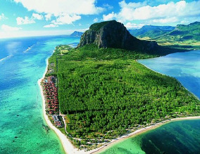
Geography of Mauritius
|
Location:
|
Southern Africa, island in
the Indian Ocean, east of Madagascar |
|
Coordinates:
|
20 17 S, 57 33 E |
|
Area:
|
total: 2,040 sq km
note: includes Agalega Islands, Cargados Carajos Shoals (Saint
Brandon), and Rodrigues
water: 10 sq km
land: 2,030 sq km |
|
Area comparative:
|
almost 11 times the size of
Washington, DC |
|
Land boundaries:
|
0 km |
|
Coastline:
|
177 km |
|
Maritime claims:
|
continental shelf:
200 NM or to the edge of the continental margin
territorial sea: 12 NM
exclusive economic zone: 200 NM |
|
Climate:
|
tropical, modified by
southeast trade winds; warm, dry winter (May to November); hot, wet,
humid summer (November to May) |
|
Terrain:
|
small coastal plain rising
to discontinuous mountains encircling central plateau |
|
Elevation extremes:
|
lowest point: Indian
Ocean 0 m
highest point: Mont Piton 828 m |
|
Natural resources:
|
arable land, fish |
|
Natural hazards:
|
cyclones (November to
April); almost completely surrounded by reefs that may pose maritime
hazards |
|
Environment current issues:
|
water pollution,
degradation of coral reefs |
|
Geography - note:
|
the main island, from which
the country derives its name, is of volcanic origin and is almost
entirely surrounded by coral reefs
|
Population of Mauritius
|
Population:
|
1,274,189 (July 2008 est.) |
|
Age structure:
|
0-14 years: 23.9% (male 149,486/female 147,621)
15-64 years: 69.5% (male 430,288/female 431,753)
65 years and over: 6.6% (male 31,939/female 49,740) |
|
Median age:
|
30.8 years |
|
Growth rate:
|
0.82% |
|
Infant mortality:
|
14.59 deaths/1,000 live births |
|
Life expectancy at birth:
|
total population: 72.63 years
male: 68.66 years
female: 76.66 years |
|
Fertility rate:
|
1.95 children born/woman |
|
Nationality:
|
noun: Mauritian(s)
adjective: Mauritian |
|
Ethnic groups:
|
Indo-Mauritian 68%, Creole 27%,
Sino-Mauritian 3%, Franco-Mauritian 2% |
|
Religions:
|
Hindu 48%, Roman Catholic 23.6%, other Christian 8.6%,
Muslim 16.6%, other 2.5%, unspecified 0.3%, none 0.4% |
|
Languages:
|
English (official), Creole, French
(official), Hindi, Urdu, Hakka, Bhojpuri |
|
Literacy:
|
definition: age 15 and over can read
and write
total population: 85.6%
male: 88.6%
female: 82.7%
|
Government
|
Country name:
|
conventional long form: Republic of
Mauritius |
|
Government type:
|
parliamentary democracy |
|
Capital:
|
Port Louis |
|
Administrative divisions:
|
9 districts and 3 dependencies*; Agalega
Islands*, Black River, Cargados Carajos Shoals*, Flacq, Grand Port, Moka, Pamplemousses,
Plaines Wilhems, Port Louis, Riviere du Rempart, Rodrigues*, Savanne |
|
Independence:
|
12 March 1968 (from UK) |
|
National holiday:
|
Independence Day, 12 March (1968) |
|
Constitution:
|
12 March 1968; amended 12 March 1992 |
|
Legal system:
|
based on French civil law system with
elements of English common law in certain areas |
|
Suffrage:
|
18 years of age; universal |
|
Executive branch:
|
chief of state: President Sir Anerood JUGNAUTH
(since 7 October 2003); Vice President Abdool Raouf BUNDHUN (since 25 February
2002)
head of government: Prime Minister Navinchandra RAMGOOLAM (since 5 July 2005)
cabinet: Council of Ministers appointed by the president on the recommendation
of the prime minister
elections: president and vice president elected by the National Assembly for
five-year terms (eligible for a second term); election last held 19 September
2008 (next to be held in 2013); prime minister and deputy prime minister
appointed by the president, responsible to the National Assembly. |
|
Legislative branch:
|
unicameral National Assembly (70 seats; 62 elected by
popular vote, 8 appointed by the election commission to give representation to various
ethnic minorities; members serve five-year terms). |
|
Judicial branch:
|
Supreme Court |
|
Political parties and leaders:
|
Alliance Sociale or AS; Hizbullah [Cehl Mohamed
FAKEEMEEAH]; Mauritian Labor Party or MLP [Navinchandra RAMGOOLAM]; Mauritian Militant
Movement or MMM [Paul BERENGER] - in coalition with MSM; Mauritian Social Democrat Party
or PMSD [Charles Xavier-Luc DUVAL]; Militant Socialist Movement or MSM [Pravind JUGNAUTH]
- governing party; Rodrigues Movement or MR [Joseph (Nicholas) Von MALLY]; Rodrigues
Peoples Organization or OPR [Serge CLAIR] |
|
Political pressure groups and leaders:
|
various labor unions |
Economy
Since independence in 1968, Mauritius has developed from a low-income,
agriculturally based economy to a middle-income diversified economy with
growing industrial, financial, and tourist sectors. For most of the period,
annual growth has been in the order of 5% to 6%. This remarkable achievement
has been reflected in more equitable income distribution, increased life
expectancy, lowered infant mortality, and a much-improved infrastructure. The
economy rests on sugar, tourism, textiles and apparel, and financial services,
and is expanding into fish processing, information and communications
technology, and hospitality and property development. Sugarcane is grown on
about 90% of the cultivated land area and accounts for 15% of export earnings.
The government's development strategy centers on creating vertical and
horizontal clusters of development in these sectors. Mauritius has attracted
more than 32,000 offshore entities, many aimed at commerce in India, South
Africa, and China. Investment in the banking sector alone has reached over $1
billion. Mauritius, with its strong textile sector, has been well poised to
take advantage of the Africa Growth and Opportunity Act (AGOA).
|
GDP:
|
$14.27 billion (2007 est.) |
|
GDP growth rate:
|
3% |
|
GDP per capita:
|
$13,100 |
|
GDP composition by sector:
|
agriculture: 5.9%
industry: 29.8%
services: 64.3% |
|
Inflation rate:
|
5% |
|
Labor force:
|
570,000 |
|
Labor force - by occupation:
|
construction and industry 36%, services
24%, agriculture and fishing 14%, trade, restaurants, hotels 16%, transportation and
communication 7%, finance 3% |
|
Unemployment:
|
9.6% |
|
Electricity production by source:
|
fossil fuel: 90.8%
hydro: 9.2%
other: 0% |
|
Industries:
|
food processing (largely sugar milling),
textiles, clothing; chemicals, metal products, transport equipment, nonelectrical
machinery; tourism |
|
Agriculture:
|
sugarcane, tea, corn, potatoes, bananas,
pulses; cattle, goats; fish |
|
Exports:
|
clothing and textiles, sugar, cut flowers,
molasses |
|
Export partners:
|
UK 31.9%, France 20.2%, US 11.4%, Madagascar 6.3%, Italy
5.4% |
|
Imports:
|
manufactured goods, capital equipment,
foodstuffs, petroleum products, chemicals |
|
Import partners:
|
France 11.4%, South Africa 10.8%, India 8.8%, China 5.7%,
Finland 5.5%, Bahrain 5.1%, Germany 4.9% |
|
Currency:
|
Mauritian rupee (MUR) |
SOURCES: The CIA World Factbook, U.S. Department of State, Area Handbook of the US Library of Congress
Copyright 2004 - 2008 worldfacts.us |